Historical Summary


|
Narrows was settled around 1778, some thirty years after the first migrants from Pennsylvania arrived in Giles County, via the Great Wagon Trail along the New River. Narrows' founding families were the French, McKensey, Hale, and Hare families.
They all settled near the confluence of Wolf Creek and the New River to take advantage of its strategic position during the river transportation era. Most of southern Narrows (the northern and southern portions of he Town are bisected by the New River) was owned by the Hale family, perhaps the wealthiest of the fouding families. Original land grants to the Hale family, dating as far back as 1793, are still in the possession of the Hale family. During the Civil War period, Narrows served as a strategic location for Confederate troops defending the Dublin-Bristol rail line from sabotage attempts by Union soldiers. The Confederate troops were stationed on Tannery Hill, which afforded them a vantage point in three directions. Although Narrows did not acquire a railroad connection until 1884, its strategic location as a military "chokepoint" enabled Confederate troops to stem the movements of the Union Army (moving east and west) by capitalizing on this natural "gap" in the mountain chain. During the Reconstruction Era, Narrows began to flourish. In 1873, the community's first U.S. Post Office opened, serving as a vital communication link between Dublin and White Sulphur Springs. During that time, consideration was given to changing the name of the town's post office to "Intermont". However, this proposal was quickly rejected for two reasons. First, the developing township would also have to assimilate to the name. Second, another Virginia community already held prior claim to the name. In 1890, Narrows' first church was established. It was Methodist, although all faiths worshipped there until a new church was built in 1922 on Main Street to accommodate the rapid growth of the Town. The economic boom of the Reconstruction Era provided Narrows with a greater ability to serve its citizenry. In the field of public safety, for example, fire protection was furnished by the Union Tanning Company. The Union Tanning Company was the largest local employer of that time and the most capable of providing the required manpower for firefighting. After the Town's water company was organized in the early 1920's, the Town assumed the responsibility of firefighting. Although portable hose reels were still purchased from the tannery, small fire houses were constructed in key points in Narrows and the first volunteer fire company was formed to use the newly installed equipment. During the 1930's, the Town's first fire truck was purchased and the police chiefe was also placed in charge of fire services. Coupled with the provision of fire safety service, Narrows recognized the need to protect the "public interest and welfare" through excellence in the body politic. For example, the Town Charter, which was granted by the General Assembly on March 14, 1904, was amended in 1948 to provide for its first Town Manager. Since that time, development standards such as zoning and subdivision ordinances have been adopted. Furthering the need to safeguard the public interest, a local planning commission was organized to regulate escalating development concerns. Giles County and Narrows both experienced growth when the Norfolk and Western railway was constructed during 1884 and 1885. Giles County's population, for instance, increased by nearly 50 percent. It went from 5,870 in 1880-1881 to 8,794 in 1884-1885. As with any transportation center, industrial growth was soon to follow. In 1880 and 1881, before the arrival of the railroad in Narrows, the only businesses in town were a flour mill, one doctor's office, and a general merchant. After the railroad connection in the mid-1880's, two saw mills were erected. Soon after, in 1910, a third mill located on Walkers Creek was purchased by two Narrows residents, Herbert Hale and George Bane. The men moved the mill to Wolf Creek. The mill provided electricity for the Town's lights between 1915 and 1916. The first municipal building was constructed in Narrows in 1921. It was a two-story, concrete block structure that stood where the present parking lot is now located. The present brick municipal building was erected in 1950. The first bank to open in Narrows was the First State Bank of Narrows, which opened its doors on September 19, 1905. Prior to the bank's opening, Narrows residents had to travel to Pearisburg, the County seat, to conduct their banking business. The first one-room public school in Narrows was instituted in 1872 by Benton Hobbs. In the mid-1980's, the school took over the old Methodist Church building on Monroe Street and built a second story. In 1908, a new building made of concrete blocks was constructed on a hill overlooking the town between Hill and College Streets. It included the first high school. A brick building was erected around 1925 adjacent to the block building. |
A new Narrows High School was built on Monroe Street in 1931, serving until the present high school was built in 1961. The brick building on the hill remained an elementary school until it burned on Christmas Day in 1941. The fire forced some of the grades into temporary quarters until the present elementary school was completed in 1949 on land purchased from the Dr. Coburn family.
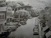
Prior to the construction of U.S. Route 460 sixty years ago, U.S. Route 100 served as the primary road to West Virginia. Route 100 ran through the downtown area in a curved fashion, giving vehicle occupants many different views of the town and surrounding topography.
Unfortunately, when U.S. Route 460 was constructed, it significantly reduced the traffic flow in the downtown area, thus greatly impacting the retail and service sector in the central business district. As a result, very little in the downtown landscape changed until the mid-1990's and with the creation of an enterprise zone.
Historical Features
Despite the rich history surrounding the development of Narrows, official documentation and preservation of historic structres has not occured on a large scale. What research has occurred indicated that the National Register of Historic Places and the Virginia Landmarks Register does not provide any official listing for the Town of Narrows. Several sites do offer themselves as potential "local" historic sites, such as the Civil War site described earlier, and the MacArthur House, which is currently being used as an inn. Likewise, the first Union Tannery site has the potential for lacal and regional promotion. There are two additional primary "points of interest" which have marketing potential as tourist sites.
North Bank Archeological Site
Research indicates that the Town of Narrows contains one archeological site, which is located on the north bank of the New River, just east of the State Route 61 bridge. This site, described as prehistoric in nature, has yielded a number of remarkable discoveries including: pottery shards, archaeologically-significant mussel shells, flint implements, and stone chips. However, studies of the site are incomplete at the present, and its real significance remains undetermined.
Mill Dam
Generally regarded as the most aesthetically appealing and valued asset of Narrows, Mill Dam signifies the indomitable spirit and strength of the community. The dam, originally built before the Civil War to provide power for a flour mill, rightfully takes its place as the cornerstone of Narrows' history. Throughout the twentieth century, the Town has rallied around the dam's preservation and today it survives as testimony to Narrows' preserverance and dedication.
Falling into a state of disrepair in 1930, the Kingrea brothers purchased the land and restored the mill to its original design. Unfortunately, the mill deteriorated with the passage of time and was eventually dismantled in the 1960's. However, in 1985 a large break occurred in the dam which led to the drainage of the pond and, to some degree, the pride of the community. Recognizing its importance, a community-wide effort was undertaken in 1986 to rebuild the dam and preserve it for the enjoyment of future generations. The $30,000 cost of rebuilding the dam was complemented by significant dedication of volunteer labor and funds.
For more historical photos please visit: https://www.facebook.com/groups/oldpicsofgilesva/
